A route optimisation algorithm can be highly effective and still produce a route that does not make sense operationally.
One of the reasons is surprisingly simple: the delivery location may have been matched to the wrong road before the optimisation even starts.
This problem is known as snap-to-road accuracy.
It becomes particularly important in dense urban environments, where highways, tunnels, bridges, ramps and local streets can exist only a few metres apart.
For a routing system, those few metres can make a major difference.
What Is Snap-to-Road?
Delivery locations usually enter a routing system as geographic coordinates: latitude and longitude.
But vehicles do not drive directly between coordinates. They travel through a road network.
Before routing or optimisation can begin, the system therefore needs to determine which road segment each coordinate belongs to. This process is commonly referred to as snapping the location to the road network.
In a simple environment, this can be straightforward.
In a dense city, it is not.
The geographically closest road is not necessarily the road from which the delivery location can actually be accessed.
A Typical Urban Routing Problem
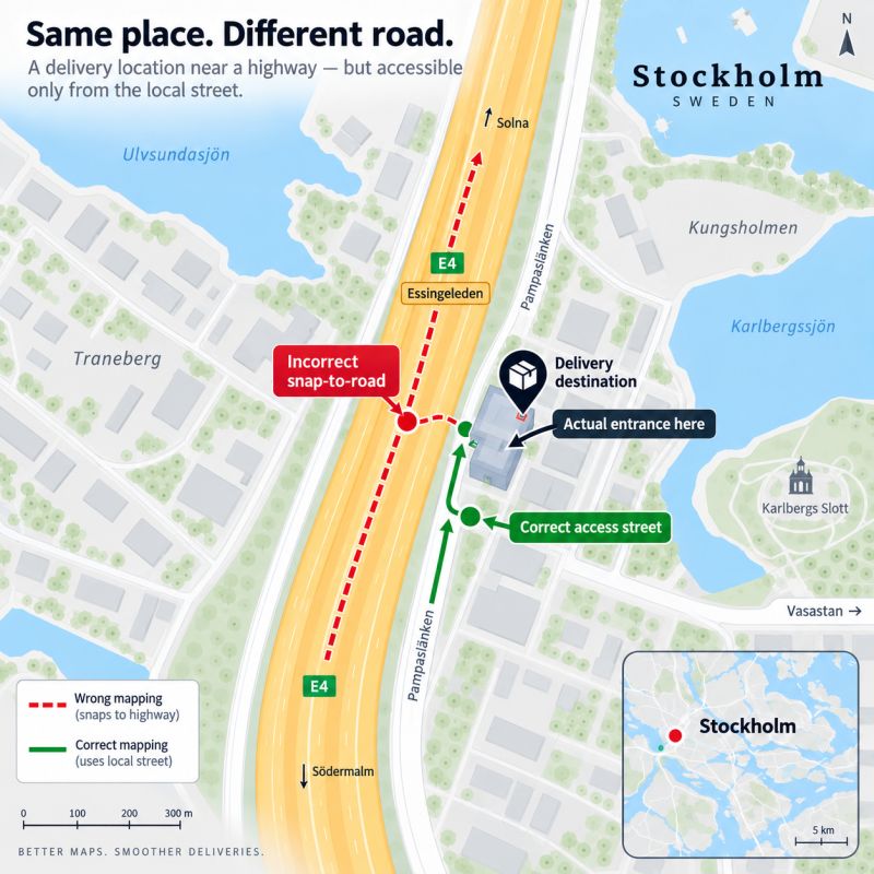
Consider a delivery address in Stockholm.
The building may physically sit next to a major highway. However, the entrance to the property is located on a local street running parallel to the highway.
From a purely geometric perspective, the highway may be closer to the delivery coordinate.
A mapping system could therefore snap the location to the highway.
Technically, the coordinate has been connected to a road.
Operationally, however, it is the wrong road.
The delivery driver may not be able to stop there, leave the highway there or access the building from that road at all.
A small mapping error at the input stage can therefore create a much larger routing error later.
The Optimisation Solver Cannot Fix Incorrect Map Matching
This distinction is important when evaluating route optimisation systems.
The optimisation solver is normally responsible for questions such as:
- In which order should the stops be visited?
- Which vehicle should serve each delivery?
- How should time windows and vehicle capacities be handled?
- Which combination of routes minimises distance, duration or operational cost?
But the solver assumes that the underlying locations and road-network connections are correct.
If a delivery point is connected to the wrong road segment, the solver may still generate a mathematically strong solution based on that incorrect input.
Better optimisation cannot compensate for incorrect road matching.
Location validation therefore needs to happen before optimisation.
How TrendRoute Validates the Road Match
At TrendRoute, we perform an additional validation step before passing a delivery location to the route optimisation solver.
Instead of relying only on proximity between the coordinate and the road network, we also cross-check the mapped road against the recipient’s address information.
- The delivery coordinate is mapped to the road network.
- The selected road segment is identified.
- The mapped road is cross-checked against the recipient’s street name and number.
- Only after the road match has been validated is the location passed to the route optimisation solver.
This additional step helps identify situations where a coordinate may have been snapped to a nearby but operationally incorrect road.
Why This Matters in Real Delivery Operations
Snap-to-road errors can be difficult to detect when looking only at optimisation KPIs.
A route may appear efficient based on total distance or calculated driving time, while still creating problems for the driver in the real world.
Incorrect road matching can potentially lead to:
- Unnecessary detours
- Incorrect approach directions
- Unrealistic ETAs
- Inaccessible delivery points
- Additional manual corrections by drivers
- Differences between planned and executed routes
These problems become more likely in areas with complex road geometry.
Typical examples include city centres, multi-level road networks, highways running alongside local streets, bridges, tunnels and roads with restricted access.
Route Quality Starts Before the Solver
Route optimisation is often discussed mainly in terms of algorithms.
Algorithms are important, but the quality of the final route also depends heavily on what happens before the solver receives the data.
Geocoding quality, road-network matching, address validation and access logic can all influence the final result.
A useful way to think about a route optimisation pipeline is:
If one of the early stages is incorrect, the error can propagate through the rest of the optimisation process.
For this reason, route quality should not only be measured by how efficiently a solver searches for a solution.
It should also be measured by how accurately the system represents the real delivery environment.
Test Route Optimisation with Your Own Locations
Many routing problems only become visible when using real-world addresses and operational data.
Use the TrendRoute Sandbox to test route optimisation scenarios, different delivery locations and routing modes.